魅力度(Attractiveness):★★★☆☆ 難易度(Difficulty):★☆☆☆☆☆ 体力度(Physical Power Level):★★☆☆☆
日光にはたくさんの山があり、大表的な山としてお爺ちゃんの白根山、お父さんの男体山に続くお母さんの女峰山です。息子の太郎山というのがあります。女峰山は2,000mを超える山の中でもっとも東に位置しています。惜しく百名山には選ばれていませんが、200名山の一つです。個人的には男体山より女峰山の方がより100名山に相応しいと思います。
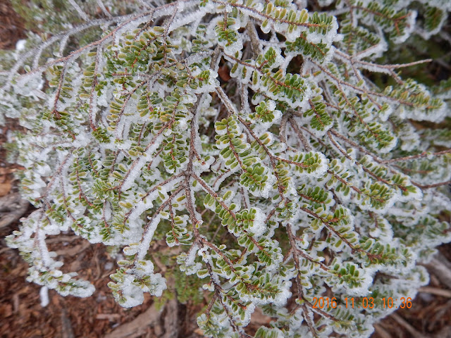
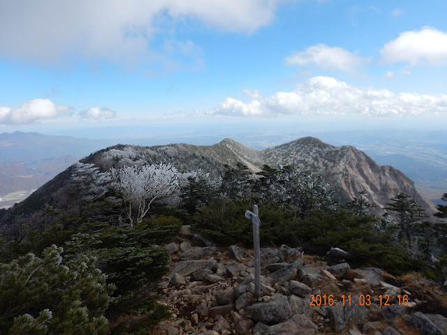
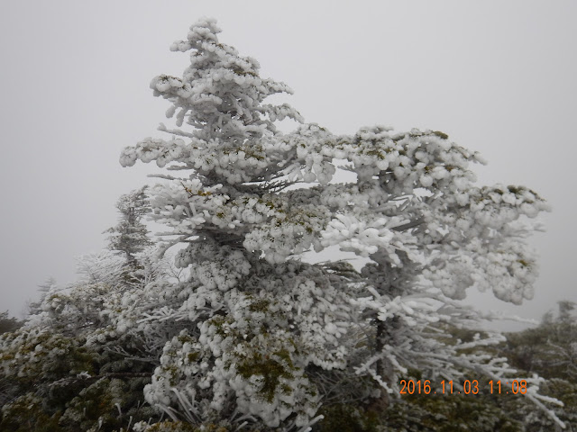
今回は来年1月の雪山でチャレンジするために山で、今回は事前調査のための下見山行でした。雪は想像もしなかったのですが、頂上付近は雪が降っていて、海老の尻尾もできていて、とんでもなく美しかったです。展望はよくなかったものの、そのおかげで雪を楽しめました。来年1月は晴れている銀の日光を眺めたいですね。
Last weekend, I climbed Mt.Nyoho located in Nikkou of Tochigi prefecture of Japan.
I climbed this mountain to check the path conditions in advance of January's climb with my mountain climbing club.
I'm taking on the role of leader at that time so I need to find the places where we can set up a tent. Because it would be very difficult to complete the climb in one day when it is covered with lots of snow so we need to camp overnight.
The leaves of Mt.Nyoho are changing right now and the air is crisp and cool. On top of that, the mountains are starting get snow so it started getting white with snow and ice near the summit. It was so great to feel snow under my feet for the first time this season. I felt winter's coming after the long summer.
Even though I couldn't enjoy the beautiful view when I reached the summit because of the bad weather, I felt good about that. Because I know we can never experience all aspects of a mountain, even if we spend a lifetime climbing it.
This time, since the weather was bad, I could enjoy the mountain covered with snow. If the weather had been good, I would have been able to see the good scenery but couldn't enjoy the snow because the temperature goes up. I hope I'll be able to see the fabulous scenery when climbing in January.


【ロープワーク】
雪が深い時は、2か所でロープを利用し、安全を確保した方がよさそう。
それほど難しい道ではないが、もしも足を滑ったらあの世へ行ける道だった。
ハイマツや木があるので、支点は作れるだろう。
【テント場】
水場に近い「テント1」が風を防げる地形になっている上、登山道から一歩離れた場所に広いスペースも確保できるため、オススメ。悪天候でそこまで行けないようであれば、「テント2」の選択肢もとれる。
もし、赤薙山までも行けないような吹雪であれば、登山は諦めて下山する。
【道のコンディション】
赤薙山の手前から登山道が狭く足場が悪いため、スノーシューはやめた方が良い。
「テント1」までは風が通るような稜線があまりないので、ワカンだけで進めそう。
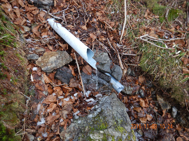
水場を過ぎたカーブ辺りから稜線が出て風が強くなるので、12本アイゼンが必要になりそう。


※駐車場にはレストハウスがあるが、早朝は営業しておらず、建物の外にはトイレも見つけられなかった。
【Movie and Pictures】
【女峰山(栃木県)*】 Nov 3, 2016, Mt.Nyoho from Donai on Vimeo.

樹氷がきれい!

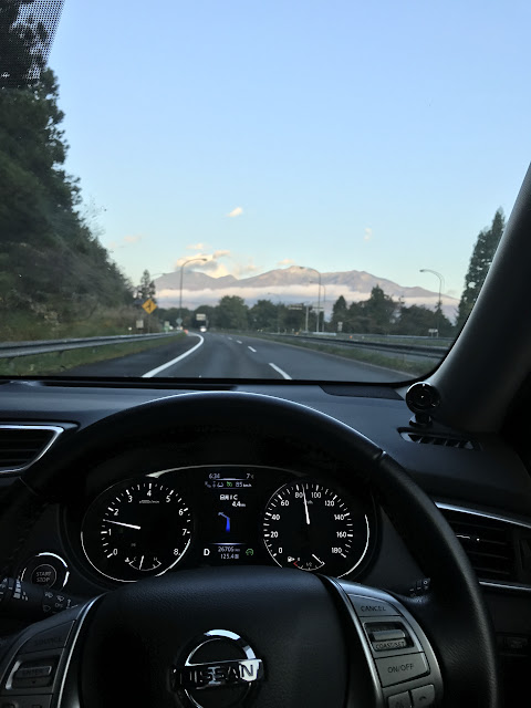
目的地の山を眺めながらゆっくりとドライブ!
ぜったい晴れると思ったけどな〜
I thought at that time it's gonna be good weather.

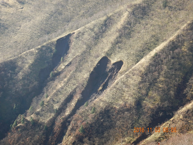
土砂崩れがハードの形で出来上がっていました。
The hart mark was made by a landslide.

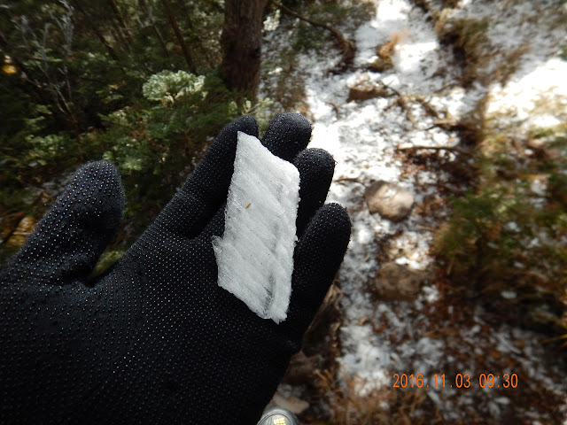
I was very sore when these ice hit my head!

おー神様!

美しすぎる!!!

いつか縦走したい。

もうちょっとで雪山だな。

Good!

きれいで美味しい水をいただけるが、雪の多い1月にどうなっているかというのは???。
【Route and Time-schedule】
7:10霧降高原駐車場 ⇒ 8:43赤薙山 ⇒ 10:24水場 ⇒ 11:10頂上 ⇒ 11:30下山開始 ⇒ 11:15赤薙山 ⇒ 14:10駐車場
【サマリー】登り:4H、下り:3H(休憩込み)、累計標高差:1,300m、総距離:13.5km

【ロープワーク】
雪が深い時は、2か所でロープを利用し、安全を確保した方がよさそう。
それほど難しい道ではないが、もしも足を滑ったらあの世へ行ける道だった。
ハイマツや木があるので、支点は作れるだろう。
【テント場】
水場に近い「テント1」が風を防げる地形になっている上、登山道から一歩離れた場所に広いスペースも確保できるため、オススメ。悪天候でそこまで行けないようであれば、「テント2」の選択肢もとれる。
もし、赤薙山までも行けないような吹雪であれば、登山は諦めて下山する。
【道のコンディション】
赤薙山の手前から登山道が狭く足場が悪いため、スノーシューはやめた方が良い。
「テント1」までは風が通るような稜線があまりないので、ワカンだけで進めそう。
水場を過ぎたカーブ辺りから稜線が出て風が強くなるので、12本アイゼンが必要になりそう。

アップダウンはほとんどなし。

4キロ時点(地図上の「テント2」)から風が通りやすい場所となるので、気温が下がりやすい。

【Traffic】
自宅 ⇒ 岩槻IC ⇒ 東北道 ⇒ 日光IC ⇒ 霧降高原駐車場※駐車場にはレストハウスがあるが、早朝は営業しておらず、建物の外にはトイレも見つけられなかった。
0 件のコメント:
コメントを投稿